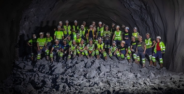
Brenner Base Tunnel under Construction
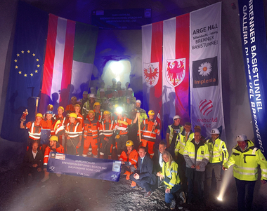
Phase 3 – the construction phase – of the Brenner Base Tunnel was started on 18th April 2011. The following article gives an overview of the state of the art of construction.
1 General information on the Brenner Base Tunnel
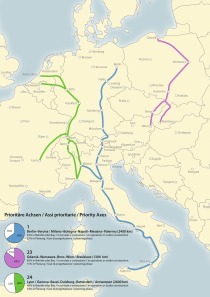
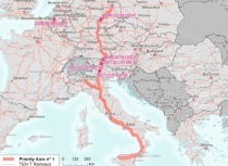
The Brenner Base Tunnel, according to the new Strategic planning of TEN-T policy (2014 to 2020), is a part of the future TEN No. 5 corridor Helsinki – Valletta (Sicily). Currently the Brenner Base Tunnel is identified as a priority section of the TEN-rail corridor from Berlin to Palermo.
Phase 3 of the Brenner Base Tunnel was started on 18th April 2011 by a decision of the shareholders‘ meeting (50 % ÖBB and 50 % TFB: from which 82 % RFI - Italian railway company and 18 % from the states of: South Tyrol, Trentino, Verona).
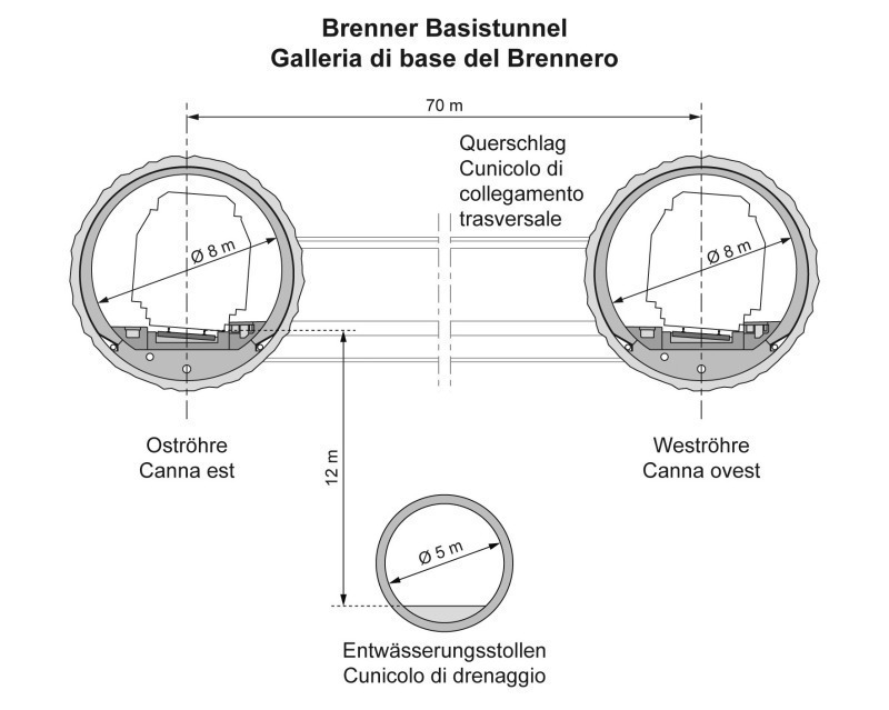
The Brenner Base Tunnel is a low-gradient railway tunnel. The tunnel stretch from Tulfes (Austria) to Fortezza (Italy). At 64 km in length it will be the longest underground railway line in the world. The maximum gradient in the main sections of the tunnel amounts to 6.7 ‰. The exploratory tunnel is centred beneath the 2 tunnels (Figure 1). It will be built in sections before beginning construction works on the main tubes, mainly to examine and prospect the rock. The results of these geological and hydrogeological tests will be used for the construction of the main tunnel. This reduces construction risk and optimizes construction costs and time. The final outfitting will be realized in the whole exploratory tunnel with the result that it can be converted into a drainage tunnel and, if need be, to a service gallery.
The most important basic features of the Brenner Base Tunnel are:
• Length: 55 + 9 = 64 km
• Gradient: 5.0 to 6.7 ‰
• Apex height of the base tunnel: 795 m a.s.l.
• Net cross-section of the main tunnel with structural tolerance – conventional tunnelling: 40.4 m2
• Net cross-section of the main tunnel with structural tolerance – mechanical tunnelling: 42 m2
• Distance between the connecting side tunnels: 300 m
2 Planning
2.1 Cross border planning design – guide design
Prior to the planning for tender procedures and the implementation planning, a cross border guide design has to be drawn up, so that the planning of the different lots takes place uniformly and the EIA prescriptions can be included in the planning. It is based on the current level of knowledge and the newest technological developments and represents the point of departure for further planning for tender procedures and other planning steps. The different experiences obtained in important projects and their methods of management and execution were assessed by a group of international experts and a proposal was subsequently created for the Brenner Base Tunnel. This approach aims to elaborate a homogenous and solid foundation for further planning activities.
Due to the differences in the design philosophies and the country-specific requirements a uniform procedure should be prepared within the planning design for geotechnical classification. Incorporating the characteristic values from the results of the exploratory tunnel. Target should be determining the selection parameters – and methods: as far as possible determining squeezing, rock creep, elasto-plastic stability, deformation, etc.
The key elements of such an “end to end” planning design are:
• Route planning review and adoption of all optimization measures and of the EIA prescriptions
• Normative foundations and technical prescriptions for tender procedures and implementation planning for every lot
• Uniform evaluation matrix for the geotechnical classification based on the Italian SIG (1997) and Austrian ÖGG guidelines
• Assessment principles, constructional design pattern for a working life of 200 years
• Preparation of detailed interface and type plans
• Definition of tolerances (tolerances depending on measurement and construction methods) considering subsequent constructions
• Preparatory measures for the railway equipment installation
Additionally, the whole route planning is recorded in a project co-ordination system: BBT-TM, represented as a transverse Mercator projection. The average project altitude of 720 m of orthometric height is defined, which corresponds to an approximate ellipsoidal height of 770 m. The project area is thus situated in the area about 10 km to the east and west of the central meridian. In the present case, the track distortion is less than 2 to 3 mm per km.
In the reference system thus created, no further rotations are necessary, as the meridian convergence is simple to calculate and the consequent reduction effect on directions is irrelevant (the convergence angle is approximately 4‘).
2.2 Tender procedures and implementation planning
The tenders for external services to the tender procedure and implementation planning will take place in 2012. There are 2 major tenders provided in the construction schedule for the tender procedure and implementation planning, namely one for the Austrian section (exploratory tunnel, main tunnel starting from the construction sites Ahrental and Wolf) and one for the Italian section (exploratory tunnel, main tunnel starting from the Mauls construction site). The planning of the boundary lots (integrating Innsbruck Station, rescue tunnel Innsbruck by-pass, Eisack crossing and Franzensfeste Station) and later the railway technical equipment take place separately. By the allocation of the tender procedure and implementation planning to the same planner it should be ensured that the findings from the exploratory tunnel program can be integrated as fully as possible in the planning of the main tunnel lot.
In Austria, a tender procedure planning with the major project elements and a detailed service description will be created on the basis of the ÖGG guidelines and the ÖNORM B 2118 for the tender for tunnel construction lots and then construction phase of the implementation planning drawn-up.
In Italy a detailed implementation planning will be created and detailed construction plans drawn-up on the basis of State Decree DM 163/2006 for the tender for construction lots.
3 Knowledge gained through model simulations
3.1 Geo-hydrological modelling
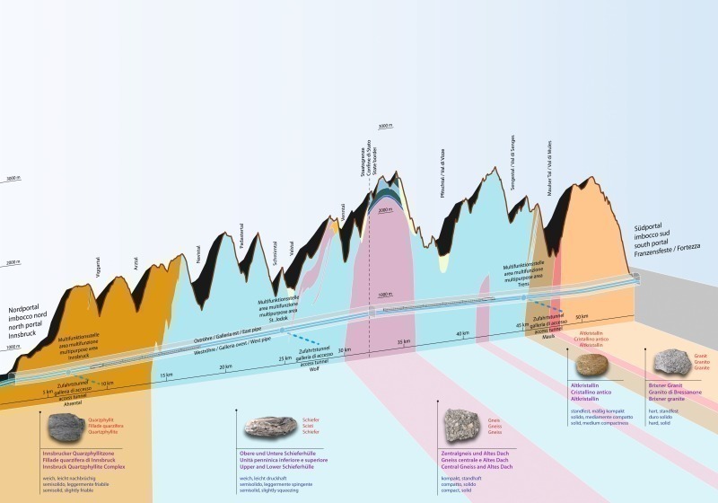
The so-called Graubunden Slate can be found north of the Brenner between the Innsbruck Quarzphyllit and the central gneiss of the Brenner. This is a fine-grained rock arising from the formation of the Alps from marine sediments. A typical feature of this rock is its pronounced schistosity. The rocks mainly appear as dark-grey “black phyllite” alternating with layers of limestone-rich phyllite.
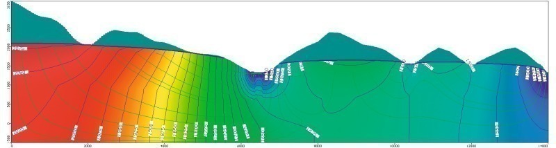
The planned tunnel route crosses the aquifer of the Hochstegen Marble in the Valser and Pfitsch valley. Due to the great importance of this aquifer, a 2D simulations model confined to the groundwater flow system in the Hochstegen Marble has been produced. The aim of this modelling is, on the one hand to gain knowledge about possible effects of the lowering of ground water through the drainage effect of the tunnel tubes and to study the effective mechanisms of seals in relation to the lowest possible drawdown of the groundwater table (Figure 2).
2-D modelling was carried out as the permeability of the adjacent rock units is lower than those of the Hochstegen Marble and thus an increase or effluent into the adjacent rock units is hydrologically negligible. The model area is therefore exclusively limited to the groundwater line of the Hochstegen Marble and the quaternary valley sediment. The whole area of the hydrogeological model section with the groundwater divide in the north and the hydraulically sealed Brenner Fault at the southern edge were selected as the model area. The model depicts a hydraulically sealed edge. The model depth was assumed at -500 m a.s.l.; below this level no further hydraulic motion is likely. The model area is crossed from the tunnels, which is why they are represented in the modelling as cross-sections.
The layering of the Hochstegen Marble has an incline of 30° to 45° to the north-east. For the modelling the Hochstegen Marble was projected in the vertical. In order to maintain the real elevations required for the calculation of the groundwater flow conditions, the profile exaggerated by the rotation was adjusted to the actual terrain profile.
Valley aquifers were made according to their lithological composition listed in Table 1 kf-zoning (10 zones). A listing of the remaining model parameters can also be found in this Table.
For the numerical modelling of groundwater flow conditions, the method of finite differences was used (Modflow 2005 the U.S. Geological Survey). Three types of boundary condition were used in the calculation.
• Boundary condition 1. Type (fixed potential): An average height was set when modelling the tunnels.
• Boundary condition 2. Type (flow boundary condition): At the upper edge of the project area, a groundwater recharge rate of 357 mm/a was applied. Another second type of boundary condition is represented by the remaining boundaries of the model section; these were modelled as impermeable boundaries without percolation, so-called no flow boundaries.
• Boundary condition 3. Type (permeability condition): A specific potential and a specific permeability for the 5 streams are defined here and the absolute levels of the streams as well as the permeability of the stream beds (so-called leakage factor) are determined.
When modelling the rock without a tunnel the permeability is varied, on the one hand to obtain a realistic mountain water table and on the other hand to faithfully reproduce the flow rates of the streams. Comparatively low sensitivity was shown when varying the leakage factor. The determination of permeability, however, has a significant impact on the simulation results. For example, the use of too high a permeability of the Hochstegen Marble (kf = 1 x 10⁻⁶ m/s) resulted in unrealistically low groundwater levels. The permeability of the valley sediment was also varied in order to be able to adjust the mountain water lines locally at the decisive points and the known heights. The result of this variational calculus is depicted in Figure 3 as a groundwater contour plan.
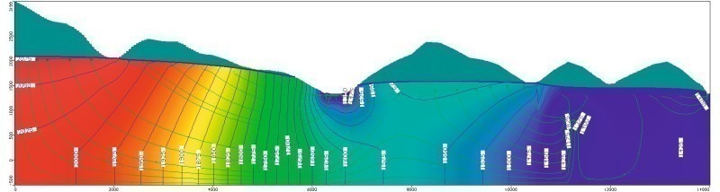
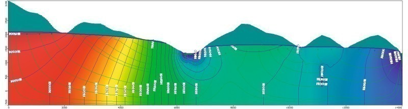
A possible lowering of water levels through the rock tunnels is depicted in Figure 4. Through an appropriate tunnel seal (injection ring: simulation using a 10 m thick layer around the tunnels with a lower permeability than that of the Hochstegen Marble) the lowering of the underground water level is reduced to low, acceptable levels (Figure 5).
3.2 Geotechnical modelling
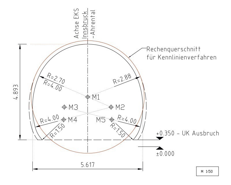
At the section between Innsbruck and the Ahrental we meet the so-called Innsbruck Quartzphyllite. It is a metamorphic rock in layers consisting mainly of minerals such as quartz, mica and feldspar. Here, the submission project of the geotechnical characteristics were experimentally determined as ranges, i.e. upper and lower values. As an example for the rock type IQP-1QP-1a-e the following parameters were determined (Table 2).
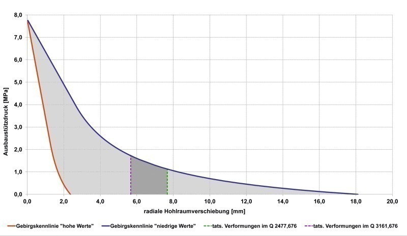
For the calculation of the characteristic rock line the model by Sulem/Panet (1987) was used. For their calculation Sulem/Panet used an MC-material model. The characteristic rock line illustrates the link between the radial displacements of the tunnel wall and the supporting effect of the inner lining. By installing supporting structures like shotcrete linings or segments, the rock pressure and the lining resistance are balanced out. The rock mass initially has an elastic and then a plastic behaviour right up to the critical area influenced by the supporting pressure of the lining. There is equilibrium at the intersection of both characteristic rock lines (Table 3).
When taking into consideration the ranges of geotechnical characteristics, several characteristic rock lines result from the calculations, as it is shown for the section of the exploratory tunnel Innsbruck-Ahrental (Figure 6, 7). With a rock pressure (supporting pressure) of 1 MPa, radial displacements of the tunnel wall of 2 mm (higher values) to 8 mm (lower values) occur.
The measured deformations in the exploratory tunnel are compared with the characteristic method or by numerical simulations (Flac 2D or 3D) computed quantities. This makes it possible to some extent to describe the rock and more specifically calculate the main tunnel by model simulations.
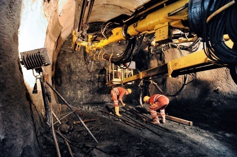
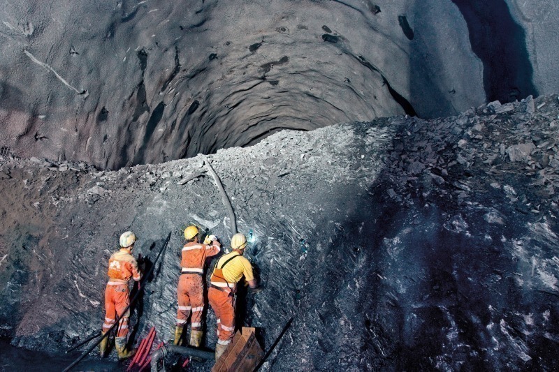
4 Construction
Of the 200 km (approximate figure with lengths rounded up) in total of tunnels, cross sections, and lateral access, exploratory and main tunnels that are to be built, some 20 km of that figure had been constructed by the end of December 2011. In the process, 11 km were bored using a double-shielded TBM (Aicha-Mules) and the remaining tunnels were excavated conventionally by blasting. So far, there have been no large water inflows recorded and the rock that has been encountered is better than the one the geological studies had envisaged.
All those at aboveground construction sites, except the 2 train stations of Innsbruck and Franzensfeste, have already been constructed. From these points, a total of 4 lateral access tunnels run down to the level of the exploratory tunnel and the rescue tunnel at the Innsbruck bypass (Figure 8).
4.1 Construction program in 2011
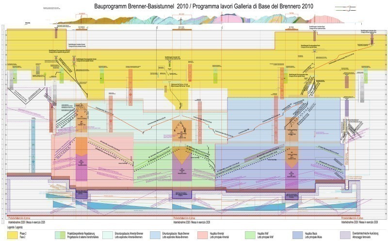
The construction program for the Brenner Base Tunnel was drawn up in 2010 on the basis of the EIA authorizations and is based on the excavation duration assessed within other comparable projects with due regard to local conditions in terms of construction logistics. After having carried out a detailed analysis, the construction program was drawn up in the form of a time-distance-diagram and discussed with technical experts. Thereby, it was necessary to take account of different excavation methods as well as the terms and deadlines for planning, tendering and awarding activities. The time-distance-diagram comprises all construction activities, starting from structural works up to the beginning of operations and all necessary planning and tendering periods. The Brenner Base Tunnel 2010 construction program was optimized based on new construction logistic experience and improved geological and hydrogeological know-how. The end of construction of the railway technical equipment is scheduled for 2025 and commissioning planned for December 2026. The construction program is updated annually; the updated construction program 2011 is depicted in Fig. 9.
According to the latest knowledge, it is assumed that about 70 % of the tunnel will be excavated using machinery and about 30 % with conventional methods.
4.2 Mules intermediate access tunnel
The 1.8 km long access tunnel, with a gradient of 8.5 %, was bored south of Mules. The access tunnel was excavated by blasting and work ended in 2009. The excavated cross section is around 105 m2. Consolidation took place with fibre-reinforced shotcrete and in partial areas with anchor elements (Superswellex). Excavation by blasting took place full surface: Compact resistant rock was found along approximately 95 % of the tunnel. Rock with structurally related fractures was determined in the remaining 5 %.
4.3 Wolf intermediate access tunnel
In summer 2010, the tunnel portal of the Wolf intermediate access tunnel was created with the passage under the existing Brenner railway. From there a utility and access tunnel, about 700 m in length, branches off in a northerly direction from the Padaster tunnel. The roughly 3.5 km long intermediate access tunnel branches out in a southerly direction with a gradient of 10 %, which will be constructed by blasting through the Graubunden Slate.
4.4 Ahrental intermediate access tunnel
The Ahrental intermediate access tunnel, which is 2.4 km long and slopes downwards by 10.5 %, has been bored conventionally through the Innsbruck Quartzphyllite since the summer of 2010. The excavated cross section is around 105 m2. After the portal, the access tunnel passes under the Brenner highway A13. In this area, the tunnel was constructed with a pipe roof, in order to achieve a load-bearing vault effect. By the end of 2011, some 1.5 km had been excavated by blasting, whereby only short advancements were possible through the flat-lying quartzphyllite slabs.
4.5 Ampass intermediate access tunnel
The Ampass intermediate access tunnel is about 1,400 m long. The excavated cross-section is approximately 35 m². Due to the reduced cross section 2 overtaking niches and 2 niches for turning manoeuvres will be excavated in the Ampass intermediate access tunnel. Work on the construction began in September 2011. The portal area has been constructed with a length of about 14 m as an artificial tunnel. The region road L283 will be relocated over the covering. Blasting will begin in March 2012. According to the geologic forecast, loose rocks of the moraine faces will occur along the first 300 m. The following 1,000 m must be excavated in the Innsbruck Quartzphyllite complex.
4.6 Innsbruck – Ahrental exploratory tunnel
A total of about 6 km were bored from the conventional bored exploratory tunnel Innsbruck - Ahrental up to end January 2012. In some sections an increased fraction behaviour with steep dipping clefts was recorded due to flat-lying foliation and waste.
4.7 Aicha – Mules exploratory tunnel
From the mechanically excavated exploratory tunnel Aicha – Mules approximately 11.5 km was broken out. Work is currently underway to the north in the area of the periadriatic seam. Using exploratory drilling the individual sections are analyzed and the blasting method and/or the first restraining elements and adapted accordingly.
5 Future prospects
The construction phase (Phase III) of the Brenner Base Tunnel was initiated on 18 April 2011. By drawing on experience from similar tunnel projects, the support of numerical simulations for expanding understanding, expert, team-oriented colleagues, and outstanding external engineering service providers and construction companies, we will build the Brenner Base Tunnel.