Building the new A52 near Essen/D: Special tunnelling Aspects
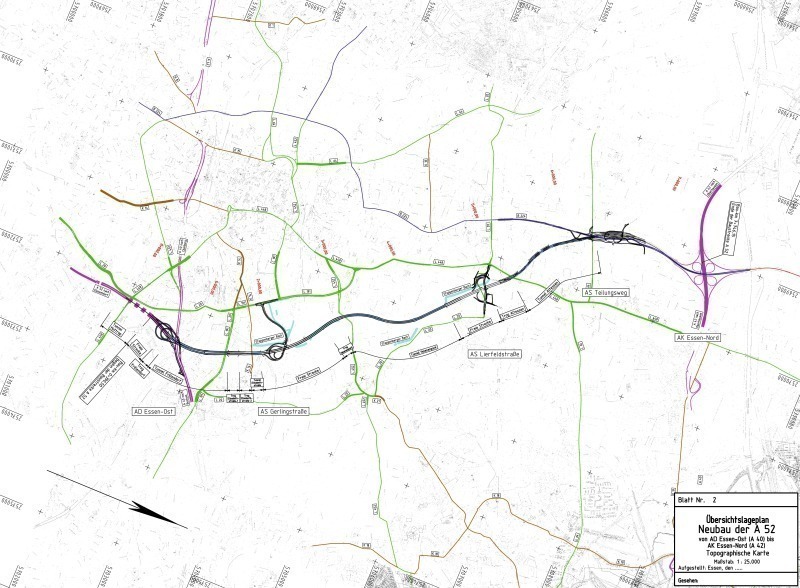
According to present planning a new part-section of the A52 from the Essen-East junction linking up with the A42 at the current Essen-North motorway hub is scheduled to be constructed by 2023. In the process the roughly 7.1 km long motorway section is to be created in a subgrade trough or tunnel. Initial planning for this major project goes back to the 1970s and has now taken on concrete form (Fig. 1).
1 Introduction
Through the gap closure between the Essen-East junction (A40) and the Essen-North hub (A42), which is at the pre-planning stage, a new continuous north-south link is to be established in the central Ruhr District in conjunction with 3 further scheduled part-sections extending to the Gelsenkirchen-Buer-West interchange.
At the same time the new motorway section representing Essen’s most important main traffic artery running north to south will result in considerable relief for interurban roads within Essen itself.
Construction costs of altogether 660 mill. Euros are earmarked for the 6-lane section of the A52 motorway running from the current Essen-East junction until it joins up with the A42 at the present Essen-North hub. The designated relatively high investment costs of some 93 mill. Euros per km of motorway when compared with other projects can be attributed to the special engineering challenges posed by a major tunnelling project, which in part runs through sophisticated geological conditions in a densely populated part of an urban catchment area.
2 Planning
The motorway section referred to here is accorded top priority in the current Federal Transport Infrastructure Plan. Already during the course of the present planning stage complexities relating to road planning, environmental effects, immission protection, tunnelling technology, engineering, operational technology, geology, tunnel safety in the event of damage and subsequent maintenance have to be taken into account.
In future the urban environment will be influenced by the construction scheme both in terms of the route itself as well as the creation of 3 new junctions. As a result a large number of further technical modifications will be required affecting the surrounding transport network as well, which can exert an influence on the secondary network through changed traffic links or signals at transport intersections.
In addition issues relating to effects of tunnelling on existing buildings with regard to subsidence, noise and vibrations as well as operating tunnels in normal or maintenance mode or cases of emergency play a major part even at the early planning stage particularly in densely populated areas.
Consequently for these reasons it is essential that all affected expert groups are involved in the planning at this stage in order to ensure that the construction project is tackled with the greatest possible functionality, safety for traffic and operation, economy and planning safety.
3 Route Alignment
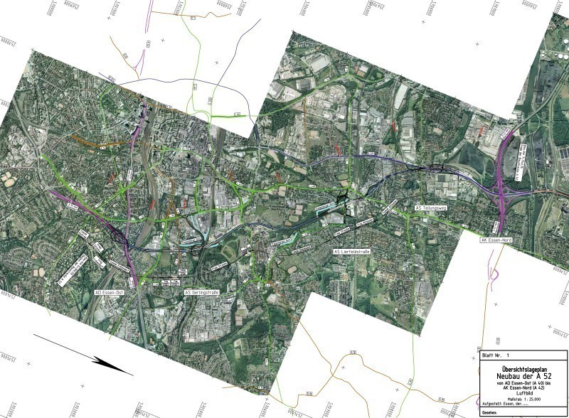
The route of the A52’s new section begins at the end of the existing development of the Essen-East junction, which is to be turned into a motorway interchange within the scope of the new project – part of which runs underground. The future “Frillendorf” Tunnel starts shortly after the already existing “Huttrop” Tunnel. It passes below a neighbouring track system with a total of 8 railway tracks as it follows the existing A40. Some of these tracks are used for a high-speed line as well as for an industrial estate in Essen-Frillendorf. Upon reaching Frillendorfer Straße the tunnel enters a trough. This is followed up by the “Gerlingstraße” junction (working title) with links to the secondary network.
After an open route section extending around 700 m the subgrade and the “Helenenpark” Tunnel follow with provisional lengths of 380 and 1,300 m respectively. Shortly after the “Helenenpark” Park Tunnel it joins up with the “Lierfeldstraße” junction (working title).
In the further course of the route the suburb of Altenessen is underpassed also by means of a tunnel. The junction in Essen-Vogelheim links up a number of inner-urban roads including the B224 with the new A52 directly behind the “Altenessen” Tunnel”. This represents the last of the urban connections before the route joins up with the Essen-North motorway hub on the existing B224 (Fig. 2).
The altogether 7.1 km long motorway section will be produced in tunnels or troughs for roughly 2/3rds of its route. The remaining part runs at low level.
4 Planning Implementation
Economic, immission protective and engineering considerations defined in particular whether the route had to be executed in the form of an open section, trough or as a tunnel. The economy of the measure concerned represents the most important criterion for assessing the variants. As a result the total costs for the construction measure as the capital sum of the investment costs and the running costs (operating/maintenance costs) per annum are determined and compared with one another.
The technical protective effect for noise produced by the variants is determining for the assessment criterion relating to immission protection. The total sum of the remaining limit value excedances is compared within an evaluation matrix. The immission protection criterion is of high significance for selecting the variants and thus ranks only second to the criterion governing economy.
In the case of the examined variants pronounced interactions between the formation of the transport facility in question (trough, semi-gallery or tunnel) and the required or rather strived for noise protection measure for construction to the west and east of the A52 resulted so that numerous variants had to be investigated iteratively in order to come up with an optimised solution.
Regarding the structural engineering criterion the sub-criteria construction method (robustness of the structure), execution/risk of construction, construction period and mass compensation were assessed and compared with each other. In this connection the sub-criterion construction period was accorded a slightly higher weighting than the other sub-criteria.
The main tunnel sections are dealt with in the following.
5 Frillendorf Tunnel
The Frillendorf Tunnel is the southernmost tunnel on the A5`s partial new section. It links up almost immediately with the existing Huttrop Tunnel. As the existing Essen-East junction is to be developed as a motorway interchange in future, the Frillendorf Tunnel is to be provided with 2 loop-shaped ramps by means of which the north-east and east-west traffic links between the existing A40 and the new A52 section that has still to be built are created. The tunnel then proceeds to pass under the existing A40, the Frillingdorfer Straße as well as 8 tracks belonging to the DB AG.
The Frillendorf Tunnel is produced by cut-and-cover save for a 400 m long section, which involves undertunnelling a number of buildings.
The individual layers of the subsoil are roughly composed as follows:
- fill
- loam
- terrace sands
- green sand (marl)
- marlstone.
Over the initial 800 m the tunnel cross-section will probably be largely located in the green sand layers and only its upper part be incorporated in the terrace sands and the layers of soil located above. Subsequently the tunnel/trough will mainly run through green sand and marlstone layers over a distance of 450 m. In areas close to the surface the tunnel/trough structures are located in the transitions zone between the green sand and the loams and terrace sands located above it.
The entire area is marked by extremely high groundwater and high flow speeds. For the cut-and-cover method the prevailing groundwater has to be collected and removed by means of bottom drainage as well as relief wells. In addition to the bottom filters, wall filers are also foreseen in order to maintain the groundwater flow running crosswise to the structure. In this way the structure will be surrounded by communicating pipes. Bulkheads are to be set up at regular intervals in a longitudinal direction in the gravel filers of the walls and floors to avoid any increase in the flow.
The prevailing groundwater will be removed within the cut-and-cover section via advance drainage. If need be this can be supported locally by applying additional mining measures.
Within the cut-and-cover section the tunnel cross-section is to be produced in the form of a twin-cell frame with closed floor. On account of the roughly 400 m long mined section requiring the tunnel bores to be splayed, the cut-and-cover measure in the transition zone to the mined section is produced using 2 single-cell splayed frames. An RQ36t is used as the standard cross-section for the tunnels or troughs, containing 2 lanes and a 0.25 m wide side strip but no hard shoulder per direction. The ramp tunnels are provided with a single-strip cross-section with 7.00 m carriageway width as well as a 1.00 m wide emergency walkway at both sides.
The structural engineering for the cut-and-cover section is largely governed by the groundwater conditions and the related uplift safety as well as the topography. The structures created by mining means depend on the geological and hydrogeological conditions as well as the prevailing overburden beneath the affected buildings.
On account of the relatively unstable subsoil the tunnel cross-section within the sections where mining means are applied is driven in the form of a drained cross-section. Towards this end first of all the 2 wall headings – which for their part are divided into roof and floor excavations – are driven over their full length. Advance drainage is also executed here. This is followed by the crown excavation between the wall headings, which is provided with an umbrella support on account of the low soil strengths within the roof zone. After the crown drive is completed, the final excavated cross-section to the floor can be produced. In order to avoid or reduce settlements to an acceptable level, compensation grouting umbrellas (KI-Schirme) are incorporated between the foundations of the buildings and the roofs of the drives.
6 Helenenpark Tunnel
The Helenenpark Tunnel is the central tunnel for the new section being built for the motorway between the Essen-East junction and the Essen-North hub.
The subsoil in this area is characterised by partially extensive fills, which are located on top of sandy and fine-sandy silts with occasional organic and humous components. An up to 1.5 m thick mud layer infiltrates the layers of silt over a length of practically 200 m. Beneath the sandy silt layers, sandy and clayey silts – in some cases green sandy silts – are to be found. Marl and in some cases solid and rock-hard pieces are located underneath them.
The hydrogeological conditions and the resultant measures devised for drainage correspond to those employed for the Frillendorf Tunnel.
The Helenenpark Tunnel has been planned as a 1,300 m long complete structure produced by cut-and-cover, whose structural engineering is largely defined by the groundwater conditions and the associated uplift safety as well as the topography.
7 Altenessen Tunnel
The Altenessen Tunnel is located in the north of the partially new A52 section built between the Essen-East junction and the Essen-North hub.
The individual layers of the subsoil by and large constitute the following:
- fill
- meadow loam (quaternary)
- meadow/terrace sands (quaternary)
- weathered loam (limestone)
- Emscher marl (limestone).
The base of the Altenessen Tunnel is mainly located in marl with a roughly 500 m section located above the Emscher marl.
The hydrogeological conditions and the resultant drainage measures correspond with those employed for the Frillendorf Tunnel and the Helenenpark Tunnel.
Underpassing the Altenessener Straße as well as intersecting the existing urban railway represents a topographical constraint as well as a special technical challenge during the tunnel route. The Altenessen Tunnel is produced by cut-and-cover as a 2-cell frame with closed floor.
8 Outlook
With a length of some 7.1 km the section from the motorway junction Essen-East to the EssenNorth motorway hub is the longest and most complex part-section of the planned gap closure to the Gelsenkirchen-Buer-West interchange. The altogether 15.4 km long gap closure when it is accomplished by 2023 will create a new continuous north-south link in the central Ruhr District and cater for up to 100,000 vehicles per 24 h.