Brenner Base Tunnel:
Importance of Preliminary Prospection
Preliminary geological prospection and constant prospection during construction are of fundamental importance. At the end of 2012, over 16 km of the exploratory tunnel of the Brenner Base Tunnel, which will run from one end to the other of the main tunnel route and will be 60 km long when it is completed, had been excavated.The following article gives an overview of the state of the art.
1 Introduction
Preliminary geological prospection and constant prospection during construction are of fundamental importance for proper excavation. Using the example of the Brenner Base Tunnel, this report describes the experience and the new knowledge obtained from the excavation of the exploratory tunnel. This case has also shown the importance of the constant recording and documentation of the geology and the pertinent geotechnical classifications as the excavation progresses, so as to chart the visible information in so-called „tunnel tapes“ [1].
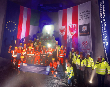
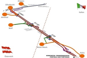
The excavation work for the Brenner Base Tunnel began in August of 2007. First of all, it was necessary to build the lateral access tunnels with the entrances to the construction sites and disposal areas. At the end of 2012, over 16 km of the exploratory tunnel, which will run from one end to the other of the main tunnel route and will be 60 km long when it is completed, had been excavated (Fig. 1).
2 Technical data on the Brenner Base Tunnel
2.1 The route of the Brenner Base Tunnel
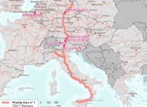
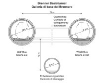
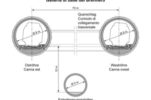
The Brenner Base Tunnel runs between Tulfers/Austria and Fortezza/Italy and has a total length of 64 km. The maximum gradient in the main sections of the tunnel amounts to 6.7 ‰. Below the 2 main tunnels and centred between them, a preliminary prospection and exploratory tunnel is being built section by section [2]. The main objective is the prospection of the rock mass, so as to reduce construction risk and optimize construction costs and time [3]. During the operational phase, this tunnel will act as a drainage channel in which supervision and maintenance work can be carried out independent of operations in the main tunnels (Fig. 2).
The most important basic features of the Brenner Base Tunnel are:
Length: 55 + 9 = 64 km
Gradient: 5.0 to 6.7 ‰
Apex height of the base tunnel: 795 a.s.l.
Net cross section of the main tunnels: about 43 m2
Distance between the connecting side tunnels: 300 m
2.2 Important geological areas
The tunnel route runs through the central part of the Eastern Alps which arose when the European and the Adriatic tectonic plates collided. This rock formation is accompanied by faults and fault zones. In the southern part of the tunnel near Mules – Alto Adige, the tunnel axis crosses the Periadriatic Fault System, an important tectonic fault line in the Alps which is 700 km long and about 1300 m wide.
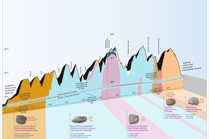
The most important geological areas and the corresponding tectonic units along the Brenner Base Tunnel from Innsbruck to Fortezza are, as follows (Fig. 3):
Innsbruck Quartzphyllite (Austroalpine)
Bündner schist area (Penninic - Tauern Window)
Lower Schieferhülle (Subpenninic - Tauern Window)
Central Gneiss - Brenner Massif (Subpenninic - Tauern Window)
Alternating Lower Schieferhülle and Bündner schists (Tauern Window)
Mica schists (Austroalpine)
Mules tonalitic „lamella“/Periadriatic fault system
Brixner Granite (Southern Alps)
To simplify, there are 4 main rock types running from north to south.
Innsbruck Quartzphyllite: Innsbruck Quartzphyllite is a metamorphic rock in layers consisting mainly of minerals such as quartz, mica and feldspar.
Schist: The Bündner schists and the Lower Schieferhülle are marine sediments and, to a lesser degree, magmatic rock that has undergone a metamorphosis during the rise of the Alps. A typical feature of this rock is its pronounced schistosity. The most important rocks are limestone mica, limestone phyllite, black phyllite and green schists. From a volumetric point of view, the most important minerals are calcite, mica and quartz and amphibolites in the green schists. Black phyllites also always contain graphite.
Gneiss is a coarsely layered crystalline metamorphic rock which was created during the formation of the Alps as a granitic rock mass. The so-called „Central Gneiss“ mainly consists of the minerals feldspar, quartz and to a lesser degree mica.
Granite is a massive crystalline magmatic rock. The fine-grained to middle-grained Brixner granite, like gneiss, also consists of feldspar, quartz and to a lesser degree mica, but its structure is not layered.
3 Overview and content of the prospection phases with respect to the geological and geotechnical planning
The geological prospection for the Brenner Base Tunnel took place in several phases. On the basis of existing feasibility studies (including [4]) the most important phase of geological prospection took place from 1999 to 2002 (pre-project phase I). In this phase, more information was obtained concerning the general geology of the project area and its characteristics as a construction site for a deep tunnel. All available existing geological data was gathered and combined. A first deep drilling campaign along the route yielded information on the geological conditions in the deep rock, Structural geological and geotechnical data was recorded on the terrain along the entire route and individual detailed mapping was carried out. Special attention was paid even in this early phase to the location and structure of fault areas [4]. In Project Phase II, which was the actual planning phase for the final project, numerous deep boreholes were sunk between 2004 and 2006, geological mapping was carried out and structural and geotechnical detailed photographs were made at multiple outcroppings and selected borehole sites [5]. The geological construction documentation from the Innsbruck bypass tunnel, which had been excavated from 1990 to 1994 and is to become part of the entire Brenner Base Tunnel system, was evaluated. An important result of this phase was the subdivision of the project areas in geologically homogeneous areas [6]. The detailed images of outcroppings in the vicinity of faults that can be attributed to certain systems also provided a picture of the general structure of the faults in the various systems [7]. On the basis of the data and the results from project phases I and II, the fundamental geotechnical forecasts for the underground conditions at the sites for the various structures were drawn up during planning for the final and authorization projects.
4 Geology of the Innsbruck-Ahrental exploratory tunnel
The Innsbruck-Ahrental exploratory tunnel runs entirely through the Innsbruck Quartzphyllite rock formation. This is an internally folded and presumably also cracked and chipped eastern Alpine rock mass unit on the northern edge of the western Tauern Window, bordering on the rock masses of the Tauern Window to the south through a ductile shear zone and, to the west, on the Ötztal-Stubai Crystalline complex through the Brenner Fault. To the north, the Quartzphyllite formation folds under the quaternary sediments of the Inn valley, through which the Inn valley fault system runs. Innsbruck Quartzphyllite consists mainly of quartz-rich phyllites (quartzphyllites), mica and quartzite schists with green schist, marble, orthogneiss and graphite phyllite inclusions. From a volumetric point of view, the most important minerals are quartzite, mica and chlorite in varying proportions with the addition of feldspar, resulting in phyllite, quartz phyllite, mica schists and quartzite schists. As for the less frequently encountered types of rock, other minerals may be present or come to the fore. This applies for example to calcite and dolomite in the case of marble, amphibolites in the case of green schists and graphite for the graphite phyllites. The relevant fault systems in the Innsbrucker Quartzphyllite rock mass can be divided into the Inn valley, the Wipp valley, the Halsl and the Ahrental fault system. These systems were already known from the prospection phases.
5 Geological and geotechnical documentation and new information obtained from the Innsbruck-Ahrental exploratory tunnel
5.1 Geological and geotechnical documentation
Excavation of the Innsbruck-Ahrental exploratory tunnel, using blasting, has been moving south-southeast from Innsbruck as of February 2010. At present (January 2013) about 4150 m of tunnel have been excavated, corresponding to km 6+250. The 2400 m long access tunnel in Ahrental was excavated, moving east-northeast, from July 2010 to October 2012. The Ahrental access tunnel meets the exploratory tunnel at TM 3630 and is also part of the Innsbruck-Ahrental prospection lot.
The excavation work is being documented according to current standards from a geological point of view, gathering a large amount of data with images of at least every second volley.
On the basis of the geological and geotechnical documentation (photos, volley reports, periodic reports, final reports, tunnel tapes and profiles) the current geological model from the final project is under constant revision. The basic documents are, in this case, a horizontal profile at tunnel level on which the extent of the structures and the lithological units are recorded, and a fault registry. This document includes every relevant fault with a detailed description.
5.2 Knowledge obtained from the exploratory tunnel
5.2.1 Geology
As regards the structure and the general location and position of the lithostratigraphic units, the main points of the forecast have proven to be correct. This also goes for the faults in the expected fault systems, meaning that faults from all 4 systems mapped during the prospection phase have been encountered in the Innsbruck Quartzphyllite and that a large part of the faults could be assigned to the known and expected systems. However, there have been certain departures from the predicted model.
a) Localisation of specific faults
The longitudinal geological profiles of the forecast for the Innsbruck-Ahrental exploratory tunnel and the Ahrental access tunnel had predicted the presence of numerous faults at tunnel level, giving the position and inclination of the faults and other important parameters such as orientation, breadth, types of rock in the faults etc.
For the already excavated stretch of the Innsbruck-Ahrental exploratory tunnel, it should be said that - considering the uncertainty of the prediction - only a small part of the predicted faults have occurred where they had been expected. In the Ahrental access tunnel, on the other hand, several faults dipping steeply to the west and belonging to the Wipp valley fault systems were predicted with a fair level of precision (see Fig. 4). Among the faults predicted at tunnel level on the basis of surface data, we should mention fault Pa01-054 which was projected in the longitudinal profile from borehole Pa-B-01/04s at a distance of about 300 m. The direction of the fault was determined using geophysical tests from the borehole (acoustic log). It was also correctly predicted that besides the other structures in the forecast, further faults belonging to the Wipp valley system would appear, especially in the western stretch of the tunnel, for which no precise location could be obtained. Differences between the forecast and the actual conditions occurred with the undocumented steeply dipping faults in the east (right-hand) side of the longitudinal profile and with unexpected flat-lying fault zones.
Both tunnels lie under the eastern Mittelgebirge range south of Innsbruck. On the surface, the area mainly consists of gentle hills. Large parts of the underground consist of quaternary loose sediment. The entire area is intensely anthropized and in the area of the exploratory tunnel it is, in part, densely populated. For all these reasons, continuous fault mapping from the surface is not possible.
b) Flat-lying faults
As already mentioned, the excavation of the Ahrental access tunnel intersected fault areas that dip gently in a northwest direction and that had not been predicted as such. Due to direction and orientation, the faults were attributed to the Ahrental fault system, in which however structures with a medium to steep dip had been predicted. The core zones of these multiple fault systems were almost 10 m thick. The faults in the Ahrental system are displaced and cut off laterally by the steeply dipping faults of the Wipp valley system.
The prediction of deep flat-lying fault zones is a well-known problem in tunnel construction [10]. If 2 different tectonic units do not actually meet in them, then these structures are difficult to predict from the surface. The main reason for this is that in contrast to the outcroppings that appear along steeply dipping brittle faults, there is hardly any apparent morphology. The surface appearance might, at best, be a flattened, terrace-like area with loose sediment layers. In the outer Wipp valley, with its many quaternary terraces and different levels of terrain, these structures are unidentifiable from the surface. To this we may add the presumed displacement by the Wipp valley fault system, which border laterally on the flat-lying faults and do not create any marked continuous structures.
c) Structure of faults and fault rock mass
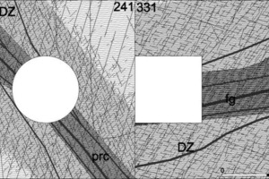
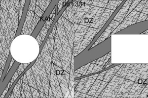
The predicted rock mass models for the various fault systems in the Innsbruck Quartzphyllite all show, besides breadth and orientation, comparable structures of the fault areas (see also [1]). They consist of a branching core zone in the central area, surrounded by damage zones on both sides (Fig. 5). The material of the core zone is given as kakiritic (loose fault breccia) and, to a lesser degree, fault gouges (cohesive fault material). The material in the damage zones is described as „loosened“. This shows a markedly increased joint density corresponding to the parameters recorded for the terrain (orientation, distance, length).
In the fault zones intersected during excavation in quartz phyllite, the material in the damage zones is tectonically loosened quartz phyllite with numerous shallow shear traces and slickensides, all of which matches the geological and geotechnical predictions. There are more marked differences however as regards the structure of the core zones. These consist mostly of heavily disturbed phyllite, characterized by close-set, mainly intensely and irregularly folded layer and shear planes with marked loosening along these surfaces. This typical fault rock for quartz phyllite cannot yet be defined „loose rock“ and cannot therefore be described as kakiritic. The term „layered protocataclastic rock“ is used. It frequently includes several shallow shear traces consisting of fault gouges.
5.2.2 Characteristic rock lines
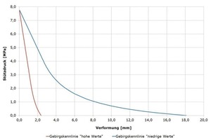
When taking into consideration the ranges of geotechnical characteristics, several characteristic rock lines result from the calculations, as is shown for the section of the Innsbruck-Ahrental exploratory tunnel. With a rock pressure (supporting pressure) of 1 Mpa, radial displacements of the tunnel wall occur ranging from 2 mm (higher values) to 8 mm (lower values) (Fig. 6).
The deformations measured in the exploratory tunnel are compared to those calculated using the characteristic line method or numerical simulations (Flac 2D and/or 3D). With this approach, the rock mass can be described by modelling and simulation and better evaluated for the main tunnel construction.
6 Knowledge gained from the Aica-Mules exploratory tunnel
The Aica-Mules exploratory tunnel, which is over 10 km long, runs entirely through Brixner granite. Geologically, 18 fault zones were expected but only 8 of these were actually encountered. Around TM 2560 an unexpected fault was intersected which caused slight deformation and cracks in the segmental lining. The largest fault is the Rio Bianco fault which had been predicted at TM 5830 with a breadth of 50 m. This fault appeared much earlier, between 5760 and 5864 m and was accompanied by numerous water inflows. At TM 6151 an unexpected, roughly 5 m thick fault was encountered running parallel to the tunnel. This fault, though geologically rather unimportant, caused heavy deformation of up to 60 cm in the segmental lining, due to its orientation parallel to the tunnel axis. This brought the TBM to a stillstand for just under 4 months.
As for water inflows, the prediction for the Aica-Mules exploratory tunnel was 150 l/s (stabilized) and 290 l/s (maximum). In fact, the trend shows stabilized inflows of 70 l/s. The maximum inflows were about 200 l/s.
The prediction for the total water flow from the Mules access tunnel was 25 l/s (stabilized) and 230 l/s (maximum). In fact, the stabilized flow is about 6 l/s and the maximum is about 10 l/s.
180 samples from the Aica exploratory tunnel resulted in a specific weight for the rock of 2,67 kN/m³. The medium uniaxial compression resistance was 142 MPa (standard deviation was 33 MPa). and 133 MPa was the predicted value. Medium abrasivity according to Cerchar was 3,87 (standard deviation 0,67).
The Brixner granite showed solid rock mass behaviour. In individual cases, events similar to rock bursts occurred. In the damage zone area of the faults, the rock face was unstable due to additional unfavourable fractured systems. In the core zone areas of the faults there were individual occurrences of heavy overstressing of the rock mass (Fig. 7).
7 Determining rock mass behaviour
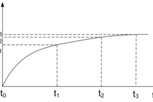
With excavation using conventional methods, deformation occurs depending on geological conditions in a first phase after blasting until the first stabilisation measures are put in place. This volumetric deformation and its extent are part of an analysis aimed at improved evaluation of the mechanical behaviour of the lining.
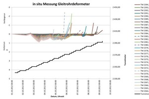
Predictions of rock behaviour (concerning the system as well) are made for an area up to 20 m in front of the current rock face. The tunnel excavation causes the rock to lose tension before the rock face. With measurements in situ (extensometer, inclinometer) the deformations and the pertinent time factors are recorded and compared with the theoretically obtained or predicted values (Fig. 8).
The first measurements did not provide new information; they did however help in carrying out in-depth and experimental tests in situ as well as numerous comparative calculations. It was shown that immediately after blasting deformation was close to a millimetre (Fig. 9).
The radial deformation of the rock mass can be explained by several theories. The u0 pre-deformation can be estimated according to Panet by using the formula 1.
The decrease in radial deformation as distance from the rock face increases was estimated with formula 2 by Sulem, Panet, Guenot, 1987.
8 Conclusions
The multiple-phase prospection based on geological surface imaging on the most diverse scales and numerous deep boreholes along the route provided geological models of the rock mass that have so far proven to be correct. In the immediate area of the boreholes, predictions were made with highly precise details of the conditions deep underground. However, along the route the prediction models have shown highly varying levels of certainty, especially concerning the prediction of specific faults at tunnel level.
For deep-lying long tunnels it is crucially important not only to carry out good surface mapping and prospection drilling but also if possible to excavate an exploratory tunnel. In the case of the Brenner Base Tunnel, this importance has already been demonstrated, as it significantly improves the evaluation of the rock mass and thereby reduces the risk in the further excavation of the main tunnel tubes.

![Comparison of the longitudinal profile in the forecast (below, [8]) and the updated profile after excavation of the 2400 m long Ahrental access tunnel (above, [9])](https://www.tunnel-online.info/imgs/tok_b4d280d64c86f97121e549aefa622b68/w300_h200_x400_y207_100841593_368b078daa.jpg)
![Fault area in the Aica-Mules exploratory tunnel [11]](https://www.tunnel-online.info/imgs/tok_6a691ee4e06055cc726012eb5ba20772/w300_h200_x400_y135_100841596_7fdab6ea94.jpg)
